
The world must take action or we will see more of these hurricanes and typhoons. I am praying for all the brave people of Mexico and others who live there and visit that they can endure what will be placed on them today and in the days to come! I pray for their safety. I am sending them love and light. Please join me to watch angels and all the positive powers that be help them..
Justin Trudeau- PLEASE TAKE ACTION ON #CLIMATEJUSTICE IMMEDIATELY. Before there are more storms/hurricanes like this.
#PrayForMexico

PLEASE URGE ALL RESIDENTS AND GUEST TO EVACUATE!! DON'T LET WHAT HAPPENED IN KATRINA HAPPEN THERE. http://tinawinterlik.blogspot.ca/2015/08/what-can-we-learn-from-hurricane-katrina.html
http://www.reuters.com/article/2015/10/23/us-mexico-storm-patricia-idUSKCN0SH16720151023
"Patricia has potential to cause massive death and destruction over a large swath of the Mexican Pacific coast, including the tourist hot spots of Puerto Vallarta and Acapulco." http://www.cnn.com/2015/10/23/americas/hurricane-patricia/
National Hurricane Centre- WARNING
http://www.nhc.noaa.gov/text/refresh/MIATCPEP5+shtml/231144.shtml
Hurricane PATRICIA Public Advisory
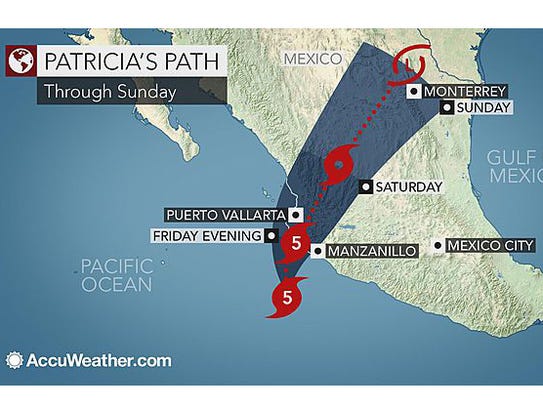
000 WTPZ35 KNHC 231448 TCPEP5 BULLETIN HURRICANE PATRICIA ADVISORY NUMBER 15 NWS NATIONAL HURRICANE CENTER MIAMI FL EP202015 1000 AM CDT FRI OCT 23 2015 ...POTENTIALLY CATASTROPHIC HURRICANE PATRICIA MOVING NORTHWARD TOWARD LANDFALL IN SOUTHWESTERN MEXICO... SUMMARY OF 1000 AM CDT...1500 UTC...INFORMATION ----------------------------------------------- LOCATION...17.6N 105.5W ABOUT 125 MI...200 KM SW OF MANZANILLO MEXICO ABOUT 195 MI...310 KM S OF CABO CORRIENTES MEXICO MAXIMUM SUSTAINED WINDS...200 MPH...325 KM/H PRESENT MOVEMENT...N OR 5 DEGREES AT 10 MPH...17 KM/H MINIMUM CENTRAL PRESSURE...880 MB...25.99 INCHES WATCHES AND WARNINGS -------------------- CHANGES WITH THIS ADVISORY: The Government of Mexico has issued a Tropical Storm Warning for the coast of Mexico north of San Blas to El Roblito. SUMMARY OF WATCHES AND WARNINGS IN EFFECT: A Hurricane Warning is in effect for... * San Blas to Punta San Telmo A Hurricane Watch is in effect for... * East of Punta San Telmo to Lazaro Cardenas A Tropical Storm Warning is in effect for... * East of Punta San Telmo to Lazaro Cardenas * North of San Blas to El Roblito A Hurricane Warning means that hurricane conditions are expected somewhere within the warning area, in this case within about 24 hours. Preparations to protect life and property should be rushed to completion. A Tropical Storm Warning means that tropical storm conditions are expected somewhere within the warning area. A Hurricane Watch means that hurricane conditions are possible within the watch area. For storm information specific to your area, please monitor products issued by your national meteorological service. DISCUSSION AND 48-HOUR OUTLOOK ------------------------------ At 1000 AM CDT (1500 UTC), the center of Hurricane Patricia was located near latitude 17.6 North, longitude 105.5 West. Patricia is now moving toward the north near 10 mph (17 km/h). A turn toward the north-northeast and a faster forward motion are expected later today, with this motion continuing tonight and Saturday. On the forecast track, the center of Patricia should cross the coast in the hurricane warning area late this afternoon or early this evening. After landfall, the center of Patricia is expected to move quickly north-northeastward across western and northern Mexico. Maximum sustained winds remain near 200 mph (325 km/h) with higher gusts. Patricia is a category 5 hurricane on the Saffir-Simpson Hurricane Wind Scale. Some fluctuations in intensity are possible today, but Patricia is expected to remain an extremely dangerous category 5 hurricane through landfall. After landfall, Patricia is forecast to rapidly weaken over the mountains of Mexico. A NOAA Hurricane Hunter aircraft is scheduled to investigate Patricia before landfall. Hurricane force winds extend outward up to 30 miles (45 km) from the center and tropical storm force winds extend outward up to 175 miles (280 km). The estimated minimum central pressure is 880 mb (25.99 inches). HAZARDS AFFECTING LAND ---------------------- WIND: Hurricane conditions should reach the hurricane warning area during the next several hours, with the worst conditions likely this afternoon and this evening. Tropical storm conditions are now spreading across portions of the warning area. Preparations to protect life and property should be rushed to completion. Hurricane conditions are possible in the hurricane watch area today. RAINFALL: Patricia is expected to produce total rainfall accumulations of 8 to 12 inches, with isolated maximum amounts of 20 inches, over the Mexican states of Nayarit, Jalisco, Colima, Michoacan and Guerrero through Saturday. These rains could produce life-threatening flash floods and mud slides. STORM SURGE: An extremely dangerous storm surge is expected to produce significant coastal flooding near and to the right of where the center makes landfall. Near the coast, the surge will be accompanied by large and destructive waves. SURF: Swells generated by Patricia are already affecting portions of the southern coast of Mexico, and will spread northwestward during the next day or so. These swells are likely to cause life-threatening surf and rip current conditions. Please consult products from your local weather office. NEXT ADVISORY ------------- Next intermediate advisory at 100 PM CDT. Next complete advisory at 400 PM CDT. $$ Forecaster Beven |
http://www.usatoday.com/story/news/world/2015/10/23/hurricane-patricia-strongest-ever-measured/74446334/
 |
| http://www.usatoday.com/story/news/world/2015/10/23/hurricane-patricia-strongest-ever-measured/74446334/ |
 |
No comments:
Post a Comment